Αρχείο:China India western border 88.jpg

Μέγεθος αυτής της προεπισκόπησης: 493 × 599 εικονοστοιχεία . Άλλες αναλύσεις: 197 × 240 εικονοστοιχεία | 395 × 480 εικονοστοιχεία | 632 × 768 εικονοστοιχεία | 1.038 × 1.262 εικονοστοιχεία.
Εικόνα σε υψηλότερη ανάλυση (1.038 × 1.262 εικονοστοιχεία, μέγεθος αρχείου: 312 KB, τύπος MIME: image/jpeg)
| Αυτό το αρχείο και η περιγραφή του προέρχονται από το Wikimedia Commons. Οι πληροφορίες από την σελίδα περιγραφής του εκεί εμφανίζονται παρακάτω. |

|
This map image could be re-created using vector graphics as an SVG file. This has several advantages; see Commons:Media for cleanup for more information. If an SVG form of this image is available, please upload it and afterwards replace this template with
{{vector version available|new image name}}.
It is recommended to name the SVG file “China India western border 88.svg”—then the template Vector version available (or Vva) does not need the new image name parameter. |


Σύνοψη
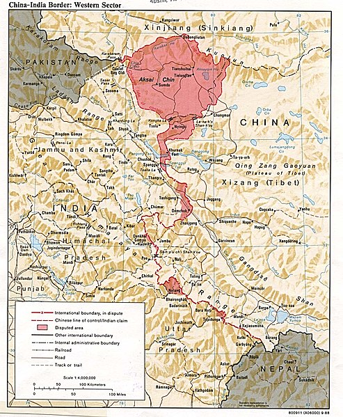
English: A map of the Western Sector of the China-India border, depicting disputed areas in this sector including Aksai Chin. (Note: India's view on the Trans-Karakoram Tract is not included.)
Taken from http://www.lib.utexas.edu/maps/middle_east_and_asia/china_indiaw_border_88.jpg
This map was produced in 1988 by the U.S. Central Intelligence Agency (https://legacy.lib.utexas.edu/maps/china.html).
Αδειοδότηση
This work is in the public domain in the United States because it is a work prepared by an officer or employee of the United States Government as part of that person’s official duties under the terms of Title 17, Chapter 1, Section 105 of the US Code.
Note: This only applies to original works of the Federal Government and not to the work of any individual U.S. state, territory, commonwealth, county, municipality, or any other subdivision. This template also does not apply to postage stamp designs published by the United States Postal Service since 1978. (See § 313.6(C)(1) of Compendium of U.S. Copyright Office Practices). It also does not apply to certain US coins; see The US Mint Terms of Use.
|
 | |
| Αυτό το αρχείο έχει χαρακτηριστεί ως απαλλαγμένο από γνωστούς περιορισμούς βάσει της νομοθεσίας περί πνευματικής ιδιοκτησίας, περιλαμβανομένων όλων των συναφών και συγγενικών δικαιωμάτων. | ||
| Annotations | This image is annotated: View the annotations at Commons |
Ιστορικό αρχείου
Κλικάρετε σε μια ημερομηνία/ώρα για να δείτε το αρχείο όπως εμφανιζόταν εκείνη τη στιγμή.
| Ώρα/Ημερομ. | Μικρογραφία | Διαστάσεις | Χρήστης | Σχόλια | |
|---|---|---|---|---|---|
| τελευταία | 15:04, 15 Νοεμβρίου 2005 | | 1.038 × 1.262 (312 KB) | Vyzasatya | China India western border depicting disputed areas in this sector including Aksai Chin. Taken from http://www.lib.utexas.edu/maps/middle_east_and_asia/china_indiaw_border_88.jpg |
Συνδέσεις αρχείου
Τα παρακάτω λήμματα συνδέουν σε αυτό το αρχείο:
Καθολική χρήση αρχείου
Τα ακόλουθα άλλα wiki χρησιμοποιούν αυτό το αρχείο:
- Χρήση σε ar.wiki.x.io
- Χρήση σε ast.wiki.x.io
- Χρήση σε as.wiki.x.io
- Χρήση σε az.wiki.x.io
- Χρήση σε be-tarask.wiki.x.io
- Χρήση σε be.wiki.x.io
- Χρήση σε bg.wiki.x.io
- Χρήση σε bh.wiki.x.io
- Χρήση σε ca.wiki.x.io
- Χρήση σε cs.wiki.x.io
- Χρήση σε de.wiki.x.io
- Χρήση σε en.wiki.x.io
- Χρήση σε en.wiktionary.org
- Χρήση σε eo.wiki.x.io
- Χρήση σε es.wiki.x.io
- Χρήση σε eu.wiki.x.io
- Χρήση σε fa.wiki.x.io
- Χρήση σε fi.wiki.x.io
- Χρήση σε fr.wiki.x.io
- Χρήση σε gl.wiki.x.io
- Χρήση σε gu.wiki.x.io
- Χρήση σε he.wiki.x.io
- Χρήση σε hi.wiki.x.io
Δείτε περισσότερη καθολική χρήση αυτού του αρχείου.